ShopDreamUp AI ArtDreamUp
Deviation Actions


Description
See also:
:origin()/pre06/98e0/th/pre/f/2015/339/6/9/germanys_loss_of_territory_by_arminius1871-d98l6ir.png)
_______________________________________________________________
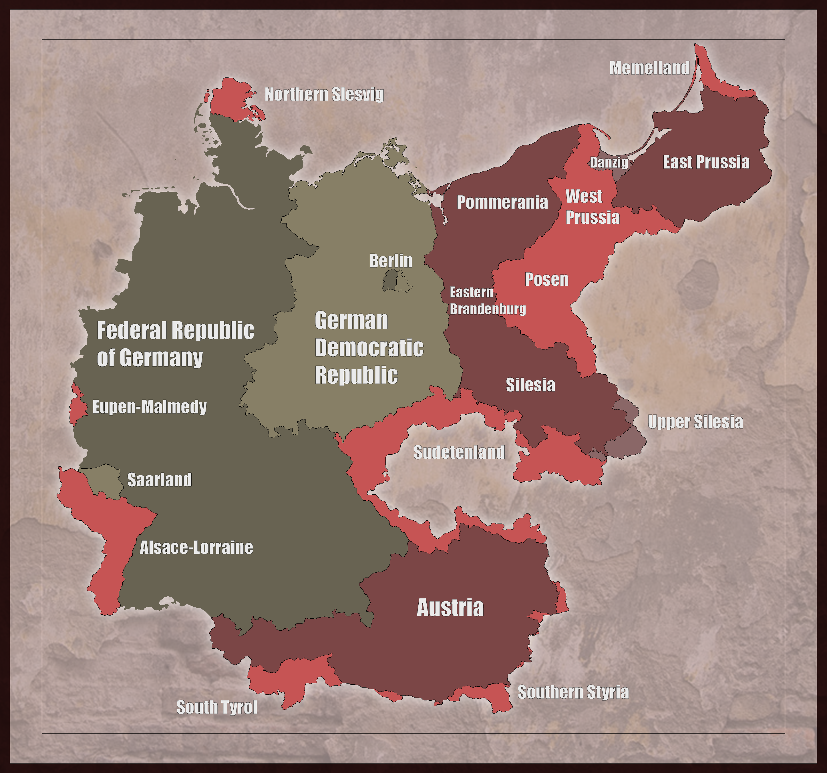
Notice: This map was not created to offend anyone, but to educate and show historical facts,
constructive criticism is always welcome, hate-comments not.
This is a map showing the territories that Germany, and german-speaking territories that Austria lost,
between 1919 and today. A short description about the regions:
Federal Republic of Germany: Germany today
Austria: Anschluss forbidden in 1919, the Republic German-Austria containing all ethnical Germans
from Austria-Hungary was forbidden as well. It united with Germany in 1938 and left Germany again
after the downfall of the 3. Reich.
Northern Schleswig: Lost after a referendum in 1919, because most of the residents were danish,
Southern Schleswig was allowed to stay in Germany.
Eupen-Malmedy: Small german communities lost in 1919 and again in 1945.
Alsace-Lorraine (Elsass-Lothringen): Lost in 1919 and again in 1945, around 90% of the residents
are Germans, Metz and the region around was always french.
South Tyrol (Südtirol): Lost 1919 and never reunited with the rest of Tyrol. Even tho Italy tried
to erase everything German there, still 70% of the residents are Germans today.
Kanaltal, South Styria (Südsteiermark), Ödenburg etc.: Smaller german regions around Austria
claimed for German-Austria, but not allowed by the allied. Most of the Germans there were
expelled, left because of bad conditions or were assimilated.
Sudetenland: Claimed by German-Austria, but forbidden by the allied. United with Germany in 1938,
lost after 1945. 99% of the Germans killed or expelled.
West Prussia (Westpreußen), Posen, Danzig: Lost in 1919 and again in 1945. Posen was mainly settled
by Poles, West-Prussia was mixed and created the so called corridor, one of many reasons that leaded
to a war with Poland.
East-Prussia (Ostpreußen): Separated from the german mainland in 1919, lost in 1945, all Germans were killed or expelled.
Pommerania (Pommern), East Brandenburg and Silesia (Schlesien): Lost in 1945, nearly all Germans were killed or expelled.
Upper-Silesia (Oberschlesien): Lost 1922 and again 1945, nearly all Germans killed or expelled.
Not included: Language islands, that were spread all over East Europe, states that identified in former centuries as Germans, such as Luxemburg, Liechtenstein, Switzerland, the Netherlands, parts of Belgium.
I didn´t mention the Saarland and partition of Germany into 4 zones in that map, too.
For more information, check:
Treaty of Versailles:
en.wikipedia.org/wiki/Treaty_o…
Potsdam conference:
en.wikipedia.org/wiki/Potsdam_…
Jalta conference:
en.wikipedia.org/wiki/Yalta_Co…
Expulsion of the Germans:
en.wikipedia.org/wiki/Flight_a…
_______________________________________________________________
Notice: This map was not created to offend anyone, but to educate and show historical facts,
constructive criticism is always welcome, hate-comments not.
This is a map showing the territories that Germany, and german-speaking territories that Austria lost,
between 1919 and today. A short description about the regions:
Federal Republic of Germany: Germany today
Austria: Anschluss forbidden in 1919, the Republic German-Austria containing all ethnical Germans
from Austria-Hungary was forbidden as well. It united with Germany in 1938 and left Germany again
after the downfall of the 3. Reich.
Northern Schleswig: Lost after a referendum in 1919, because most of the residents were danish,
Southern Schleswig was allowed to stay in Germany.
Eupen-Malmedy: Small german communities lost in 1919 and again in 1945.
Alsace-Lorraine (Elsass-Lothringen): Lost in 1919 and again in 1945, around 90% of the residents
are Germans, Metz and the region around was always french.
South Tyrol (Südtirol): Lost 1919 and never reunited with the rest of Tyrol. Even tho Italy tried
to erase everything German there, still 70% of the residents are Germans today.
Kanaltal, South Styria (Südsteiermark), Ödenburg etc.: Smaller german regions around Austria
claimed for German-Austria, but not allowed by the allied. Most of the Germans there were
expelled, left because of bad conditions or were assimilated.
Sudetenland: Claimed by German-Austria, but forbidden by the allied. United with Germany in 1938,
lost after 1945. 99% of the Germans killed or expelled.
West Prussia (Westpreußen), Posen, Danzig: Lost in 1919 and again in 1945. Posen was mainly settled
by Poles, West-Prussia was mixed and created the so called corridor, one of many reasons that leaded
to a war with Poland.
East-Prussia (Ostpreußen): Separated from the german mainland in 1919, lost in 1945, all Germans were killed or expelled.
Pommerania (Pommern), East Brandenburg and Silesia (Schlesien): Lost in 1945, nearly all Germans were killed or expelled.
Upper-Silesia (Oberschlesien): Lost 1922 and again 1945, nearly all Germans killed or expelled.
Not included: Language islands, that were spread all over East Europe, states that identified in former centuries as Germans, such as Luxemburg, Liechtenstein, Switzerland, the Netherlands, parts of Belgium.
I didn´t mention the Saarland and partition of Germany into 4 zones in that map, too.
For more information, check:
Treaty of Versailles:
en.wikipedia.org/wiki/Treaty_o…
Potsdam conference:
en.wikipedia.org/wiki/Potsdam_…
Jalta conference:
en.wikipedia.org/wiki/Yalta_Co…
Expulsion of the Germans:
en.wikipedia.org/wiki/Flight_a…
Image size
2892x2705px 3.81 MB
© 2014 - 2024 Arminius1871
Comments435
Join the community to add your comment. Already a deviant? Log In
I know my Opinion might make People Pissed but fuck it, I believe Germany has the right to reclaim its eastern borders that has been Unjustly taken away.